Labor Day Weekend is here, and the big question on everyone’s mind is “What is Hermine going to do?” We’ll try to answer that as best as we can right now.
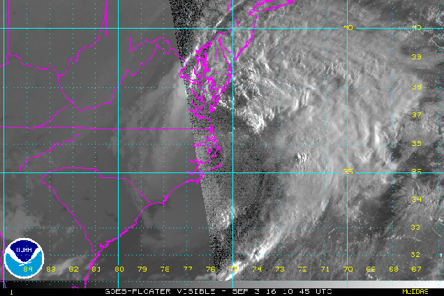
First, we’ll give you the facts. As of 2pm EDT, Hermine was centered about 90 miles east of Duck, North Carolina, moving toward the east at 10 mph. Maximum sustained winds are near 70 mph. Hermine is now a “post-tropical” storm. What does that mean? Well, to start with, it means that’s it’s no longer tropical. It’s more like a typical Nor’easter that we see throughout the fall, winter, and spring. As you can see in the satellite loop above, most of the thunderstorm activity is now well north of the center of circulation. Tropical systems contain thunderstorm activity concentrated near the center of the storm.

Despite the fact that Hermine is no longer tropical, Tropical Storm Warnings remain in effect for the East Coast from Ocracoke Inlet, North Carolina to Watch Hill, Rhode Island. A Tropical Storm Watch is in effect from Watch Hill up to Sagamore Beach, Massachusetts, which includes all of Cape Cod, the Islands, and the coast of Rhode Island.
So, if it’s no longer tropical, why are there tropical storm watches and warnings in effect? There are two reasons for this. The first, and simplest one, is the fact that there is a chance Hermine could re-acquire tropical characteristics as it sits over the warm waters of the Gulf Stream over the next few days. The other reason is related to Sandy. As you may recall, when Sandy slammed into New Jersey in 2012, there were no hurricane warnings in effect, despite the fact that Sandy was still a Category 1 hurricane while offshore. The reason there were not warnings was because Sandy was expected to become “post-tropical” before landfall, and the rules that the Hurricane Center had to abide by at the time did not allow them to issue watches/warnings if the system was not expected to impact the coast as a tropical system. (Yeah, we think it was stupid too.) So, they changed those rules, and this is the first test of them.

So, what does the future actually hold for Hermine? Hermine will stall out east of the Delmarva Peninsula tonight and Sunday as it gets stuck under an upper-level low pressure system. It will then drift around south of Long Island for a few days. While it’s sitting over the warm water there, it could become a tropical system again (possibly even a hurricane), but that won’t last too long. Why? As it sits over the same area, it will churn up the waters, which will bring cooler water to the surface through a mechanism called “upwelling.” As this cooler water comes up, the system will lose the warm water it needs to sustain a tropical system, and then lose any tropical characteristics it may have gotten back. In other words, it’ll be “post-tropical” again.

In terms of sensible weather, Hermine is going to lay the smack down on the Mid-Atlantic states. Rough surf will pound the coast, especially in New Jersey, for several days, along with strong winds right along the coast. Wind gusts of 40-60 mph are expected along the Mid-Atlantic coast, along with some periods of rain, though the heaviest rain should stay off shore for the most part.
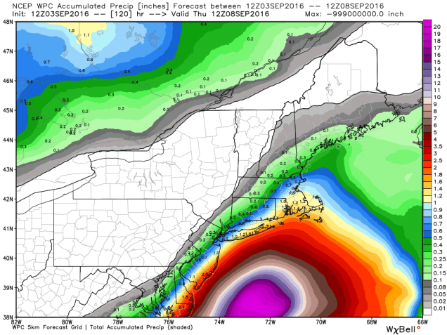
What about here in New England? We’re going to escape the brunt of it. There will be some very rough seas, starting on Sunday and likely continuing through at least Wednesday. It’s probably a good idea to stay out of the water if you’re heading to the beach, as the risk for rip currents will be high. Likewise, you probably don’t want to be heading out on a boat, with seas of 10-20 feet expected. If you’re taking one of the ferries to the Vineyard, Nantucket, or Block Island, there will likely be times where they have to cancel them due to rough seas. In terms of winds, the strong winds are likely right along the South Coast and across the Cape and Islands. Wind gusts of 30-40 mph or more are likely at times right through at least Tuesday. The bulk of the rain will stay to our south, but periodic showers and occasional batches of steady rain will come through at times over the next several days. The graphic above might be overdone in terms of how much rainfall we’ll get, but there will likely be some rain at times, especially the farther south you head.
Hermine likely won’t start to move out of the picture until the latter half of the week. Until then, we’ll just head to deal with clouds, periodic showers, occasionally strong winds, and rough surf for several days. In other words, it’ll feel like a typical April week, expect temperatures will be in the upper 60s and 70s instead of 40s and 50s.
