If you’re planning to head “over the river and through the woods to grandfather’s house” for your Thanksgiving dinner, well, you won’t need a sleigh to get there. You will probably need a coat and maybe an umbrella too.
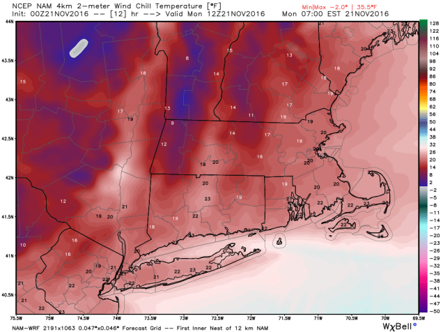
If the snowflakes that many of us saw Sunday evening weren’t enough of a hint, the wind chill when you step outside today will be a bigger one – we’re moved into a colder pattern. Don’t worry, there still aren’t any big snowstorms in the immediate future, but there also aren’t any days where you can walk around in shorts and be comfortable.
We start the week off with low pressure moving across Northern New England and into Atlantic Canada. This will result in blustery (there’s a word you only hear used in the winter) and cool conditions for Monday and Tuesday. A few more snow showers are possible on Monday as an upper-level low pressure area swings through the region.High pressure briefly builds in for Wednesday, but the next storm system will be moving eastward right on its heels. Thanksgiving will be mainly cloudy with a few showers possible, and some wet snow could mix in if the showers arrive early enough in the day, mainly north and west of Boston. Black Friday starts off dry (if you’re heading out for the Midnight Specials), but another weak system will quickly approach, with more showers possible by evening, continuing into Saturday when a period of steadier rain is possible. Blustery (there’s that word again!) and cool conditions return on Sunday.
Monday: Intervals of clouds and sunshine, windy, chance for a few snow or rain showers. High 33-40.
Monday night: Partly cloudy to clear, breezy. Low 26-33.
Tuesday: Partly to mostly sunny, still breezy. High 36-43.
Tuesday night: Mostly clear skies. Low 25-32.
Wednesday: A sunny start, then clouds return in the afternoon. High 37-44.
Thursday: Mostly cloudy with a chance of showers, possibly mixed with some wet snow early in the day. High 39-46.
Friday: Plenty of clouds, chance for a few showers, especially late in the day and at night. High 43-50.
Saturday: Rain tapers off to showers before ending late in the day. High 42-49.
Sunday:A mix of sun and clouds, breezy. High 40-47.
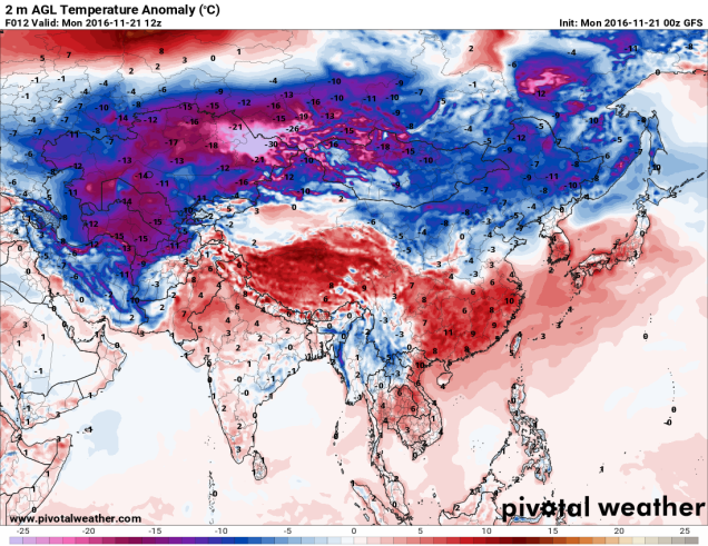
Before you complain about how cold it is, just remember, it could be a LOT worse. Over in Siberia, Mongolia, and Kazakhstan, temperatures today will be 20 to 40 below zero. That’s 30 to 50 or more degrees below normal. Our temperatures, while chilly, will “only” be 10-15 degrees below normal today.