Well, after a week of sunshine and summer-like warmth in Florida and the Bahamas, it’s back to reality for your favorite forecasters here at Storm HQ. And man, is that reality going to be harsh.
As this post is being written, snow is breaking out across Southern New England, with a change to rain already occurring across the Cape. That rain/snow line will gradually head northward early Monday morning, reaching southern New Hampshire by mid-to-late morning, though we could see a period of sleet and/or freezing rain before everything goes over to all rain. It looks like everything ends by early afternoon. While we’re not looking at a lot of snow, the combination of snow and or mixed precipitation will make a mess of the morning commute, so keep that in mind when you head out the door in the morning.

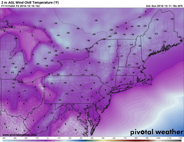
Once the storm pulls away, high pressure builds in for Monday night and Tuesday, with drier and seasonably cool conditions expected. Wednesday could be an interesting day. Right now, it looks like we’ll stay dry as a storm system passes south of the region. However, some of the models bring the storm a little farther north, which could result in some rain or snow, especially south of Boston. Once that passes by, an arctic cold front will cross the region on Thursday. Some snow squalls may accompany the front, but what’s behind it will get your attention. While Thursday will be a rather chilly day, Thursday night and Friday will feature some of the coldest air so far this season, with lows possibly dropping into the single numbers virtually everywhere Friday morning, and highs Friday afternoon staying in the teens and lower 20s. Wind chills will be well below zero, especially in the morning. The good news is that the cold air will be short-lived. As a storm system heads into the Great Lakes next weekend, south to southwest winds will pump warmer air into the region. Snow will develop ahead of the system on Saturday, but should change over to rain as warmer air moves in both aloft and at the surface. In fact, Sunday could even feature above normal temperatures, though it could also be accompanied by some rainfall. We’ll worry about that storm later i n the week.
Monday: A wintry mix of snow, sleet, and freezing rain changing to all rain from south to north during the morning, ending by mid-afternoon. Some clearing developing late in the day. High 36-43 from the Merrimack Valley northward, 43-50 south of the Merrimack Valley.
Monday night: Becoming mostly clear. Low 24-31.
Tuesday: Sunshine and a few clouds, breezy. High 34-41.
Tuesday night: Partly cloudy. Low 21-28.
Wednesday: A mix of sun and clouds, slight chance for rain or snow south of Boston late in the day and at night. High 33-4o.
Thursday: Partly to mostly cloudy, chance for snow squalls. High 21-28.
Friday: Partly to mostly sunny, windy, and cold. High 14-21.
Saturday: Becoming cloudy with snow developing, likely changing to a wintry mix and eventually plain rain at night. High 30-37.
Sunday: Cloudy and breezy with rain tapering off and ending. High 40-47, though there is the potential for temperatures to jump well into the 50s, especially from Boston southward..
