“Get in, sit down, shut up, and hold on” – Toby Keith
Ladies and gentlemen, please make sure your safety belts are securely fastened, as this rollercoaster is ready to go. Yup, the weather will go through several changes over the next few days, giving us a little of everything – howling winds, bitterly cold wind chills, snow squalls, sleet, freezing rain, heavy rain, unseasonably mild temperatures. And that’s just before the weekend is over.
We’ll start with Thursday. A series of arctic cold fronts will cross the region. Some snow squalls may accompany the fronts, so you’ll need to be prepared for that if you’re out and about during the day. These are the winter equivalent of summer thunderstorms. They’re impossible to predict ahead of time, usually don’t last too long, but can have severe impacts if you get caught in one. Visibility can drop to near zero in an instant, a quick inch or two of snow could accumulate, and the next town over could see nothing at all.

While the snow squalls can be a high-impact but localized event, the strong winds and bitterly cold temperatures will be felt region-wide. Northwest winds of 15-30 mph are likely, with gusts upwards of 50-60 mph possible, especially Thursday afternoon into Friday morning. High Wind Watches have been posted for parts of the region. If you have any loose objects outside, such as trash barrels, Christmas decorations, small children, etc, you may want to consider bringing them inside, so that they don’t blow away.

These gusty winds will also usher some of the coldest air so far this winter into the region. Most days, the day starts off cool, warms up until mid-afternoon, then cools off again as the sun goes down. Thursday will not be one of those days. We’ll start the day with temperatures in the 30s, but temperatures will drop into the 20s by midday, then keep dropping. By Friday morning, most places will see temperatures in the single numbers, with some sub-zero readings possible. When you factor in the wind, the wind chill will be 15 to 25 below zero in many areas. Make sure you’re all bundled up if you have to head outside for any reason at all. Better yet, stay inside, it’s easier.

The good news is, the cold air will be short-lived. The bad news is, the transition from the arctic air will be rather messy. A storm system will head up the St. Lawrence Valley this weekend. Precipitation will develop ahead of this system before sunrise Saturday morning. That precipitation will start as snow, but as warmer air moves in aloft, it will start to change over. How quick that changeover occurs is the big question mark.

Cold air will likely remain entrenched at the surface, especially away from the coastline. With warm air moving in aloft, that means we’ll likely see a changeover to sleet and/or freezing rain across the interior Saturday afternoon. Along the coast, a quick change to rain is likely, as water temperatures remain in the 40s, which will help warm things up fairly quickly near the shoreline. Eventually, that warmer air will move in at the surface across the entire area, with a change to plain rain expected overnight. Before that changeover happens, we’ll probably see snowfall accumulations of 1-3″ south and east of I-95, including the Boston and Providence metropolitan areas. North and west of I-95, we’re looking at 2-5″ of snow, with the possibility of some sleet or ice accretion. Please keep this in mind if you have plans in this region Saturday afternoon/evening.
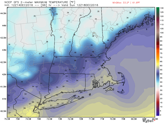
OK, so it warms up Saturday night and everything changes to rain. End of story, right? Nope, the ride isn’t over yet. By Sunday morning, temperatures will be in the 40s to lower 50s north and west of Boston, with 50s and possibly even some 60s from Boston southward. So, Sunday will be a nice warm day, right? Nope. Temperatures will peak in the morning, then drop again throughout the day as the system drags a strong cold front across the region. In fact, if the rain is slow to depart, it could change back over to some snow or sleet before ending in the afternoon. It probably won’t accumulate, but with wet roads and sharply falling temperatures, we could see some black ice develop on many area roadways. Again, just one more thing to keep in mind in you are heading out and about late Sunday afternoon or evening.
Things start to calm down after that. Monday will be quite chilly again, with highs only in the 20s, and gusty winds keeping wind chills close to zero. Temperatures start to moderate next week, and a late-week system could bring in some rain. Right now, it’s not looking like a White Christmas, but things can still change. Beyond that? Well, the GFS model gave us a good laugh this afternoon.

