It seems as though we went through this last week, but once again, after a taste of early Spring, Mother Nature is about to remind us that March can still bring plenty of wintry weather to the area.
Today is the transition day, as strong winds usher much colder air into the region behind a cold front that crossed the region late Wednesday night. While temperatures are still in the 40s, things are about to change, and most of you probably won’t like it. That cold front will stall out south of New England today, and low pressure will ride along it across the Mid-Atlantic states, passing south of us on Friday. Meanwhile, high pressure will build in north of New England, bringing plenty of cold air with it. Let’s see now, cold air moving in from the north and moisture moving in from the south. What happens when you combine those? That’s right, you get SNOW! Luckily, we’re not looking at a lot of snow this time. Let’s get to the details:
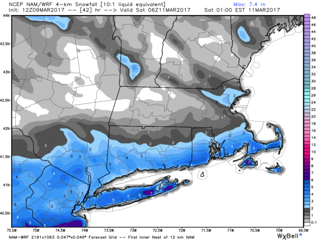
Snow should start to develop early in the morning, possibly even starting as a little rain across Cape Cod and southeastern Massachusetts. The snow may fall at a pretty good clip during the morning hours, tapering off and ending during the afternoon.Since we’re into mid-March, the sun angle is roughly the same as the end of September. In other words, fairly strong. So, once we get past sunrise, even though it’ll be cloudy, the snow will have a tougher time sticking to paved surfaces. That’s the good news. The bad news is that a lot of the snow will fall before then, so the roads may not be that pretty for the morning commute.

OK, so the snow ends in the afternoon and we’re done right? As noted college football analyst Lee Corso used to say “Not so fast my friend”. As the storm moves into the Gulf of Maine, a piece of energy, called a Norlun trough (Explained here by Matt Noyes), may produce some additional light snow from the North Shore up into southern New Hampshire and south coastal Maine through the evening hours. It won’t amount to much, but could be just enough to screw up the evening commute well north of Boston.
So, how much snow are we looking at? North of the Mass Pike, probably less than an inch, if any snow falls at all. From the North Shore into Boston and it’s immediate southern and western suburbs, probably 1-2 inches. For the South Coast, roughly south of Route 44, 2-4 inches should do it, with a little more possible across parts of the Cape and Islands.
All in all, not a big deal, especially by New England standards. What will be a big deal is the cold air behind the storm. Similar to last Saturday, this Saturday will be quite chilly, especially with fresh snowcover. High temperatures may struggle to get into the lower 20s, but wind chills will be in the single numbers and below zero. So, if you’re heading outside, make sure you bundle up. It’ll feel more like January than March.
Finally, we’re aware of the uncontrolled hype on the Internet (and TV) about a potentially major snowstorm on Tuesday. Right now, it’s a potential storm and nothing else. We’ll certainly keep our eyes on it, and if a threat does materialize, we’ll let you know well in advance. For now though, it’s nothing more than a figment of the computer models’ imaginations. We don’t participate in hype or speculation here at StormHQ, so we’re going to leave it at that.
