We apologize for the brief post this week, but we wanted to make sure we still provided you with an update, especially since Monday could be an active day.
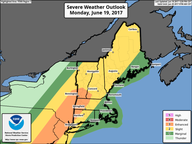
A cold front will approach the region on Monday, and with a warm and humid airmass in place, that front will likely trigger some strong to severe thunderstorms during the afternoon and evening. The strongest storms will likely occur west of our area, but some of them will likely survive into eastern New England. Some of the storms will produce heavy downpours, strong winds, hail, and possibly even a tornado or two.
High pressure will build in for the middle of the week with much drier conditions. The high slides offshore late in the week, allowing warm and humid conditions to return. Another front approaches next weekend, with more showers and thunderstorms possible.
Monday: Becoming cloudy and breezy with showers and thunderstorms developing, some of which could become strong to severe. High 80-87, cooler along the South Coast.
Monday night: Showers and thunderstorms taper off in the evening, then skies clear out late at night. Low 65-72.
Tuesday: Becoming mostly sunny. High 77-84.
Tuesday night: Clear to partly cloudy. Low 57-64.
Wednesday: Sunshine and some afternoon clouds. High 75-82.
Thursday: A sunny start, high clouds start to move in during the afternoon. High 76-83.
Friday: A mix of sun and clouds, warmer, and more humid, with a chance for a few showers and thunderstorms. High 81-88, cooler along the South Coast.
Saturday: More clouds than sun with more showers and thunderstorms possible. High 78-85.
Sunday: A mix of sun and clouds, chance for a shower or thunderstorm. High 76-83.

The tropics have also awakened. There a disturbance east of the Lesser Antilles that could become a tropical depression on Monday. Tropical Storm Warnings have already been issued for some of the islands. A second disturbance near the Yucatan could become more of a threat to the Gulf of Mexico later this week.
