While everyone has been enjoying the extended summer around here, one thing that hasn’t been noticed by many is the recurrence of drought conditions across the region. However, that drought may be on the way out……again.
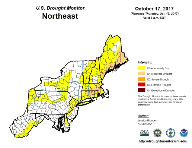
As you may recall, we had a fairly significant drought around here in 2016 and early in 2017. By the end of the winter, the pattern shifted, and we started getting rain…a lot of it. This wiped out the drought across the region by early summer. Everyone’s lawn was green again and once it started getting warm, everyone was happy. Then, the rains essentially stopped again. Since it was dry and warm for the latter half of summer and into fall, nobody really complained that much. Sure, lawns weren’t so green any more, and maybe the foliage wasn’t as spectacular as usual, but it was in the 70s in October for days on end! Well, the pattern is shifting once again.
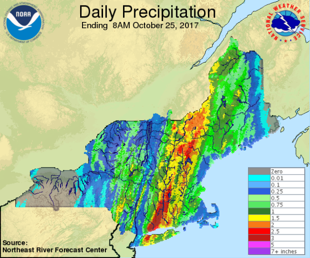
The changes already started on Tuesday. Heavy rain and thunderstorms moved slowly across the region. Rainfall totals of 1.5 to 4.5 inches were observed, with the heaviest amounts in the Connecticut Valley. Localized flooding was observed with the heavy rain, but most rivers and streams were running fairly low, so river flooding isn’t a concern at the moment. While all this rain at once isn’t always good, it will help to put a dent in the drought, and eliminate some of the rainfall deficit we’ve accumulated since the beginning of summer.
As you may have noticed, the heavy rain of the past 24 hours has pushed offshore, but we’re not done with it yet. A cold front is slowly making its way across the region, and while temperatures will drop back to normal over the next few days, it will bring us more rain today and Thursday. As waves of low pressure ride up the front, they will bring more rainfall into the area, some of it heavy. For the rest of Wednesday, we can expect showers and drizzle, with some occasional bouts of steadier and heavier rain, especially in eastern New England. On Thursday, a stronger wave of low pressure will ride up the front, bringing another round of heavy rain into the region. Once again, the heaviest rain will be focused in eastern areas, with some downpours likely.

The wave moves out, the front pushes offshore, and high pressure builds in for Friday and Saturday with sunshine and more seasonable temperatures. Meanwhile, another front will be approaching from the west. The storm system responsible for this front will produce the first significant snowstorm of the season from the Dakotas into the Great Lakes over the next few days. (Don’t worry, we’re not expecting any snow here.) Meanwhile, well to the south, there is a disturbance in the western Caribbean that is being monitored for development. It could become a tropical depression by this weekend before heading northward. Whether it develops or not, the system itself will likely get absorbed by the front approaching from the west, adding plenty of moisture. The result is another round of heavy rain across the region Sunday into Monday. Right now, it looks like the heaviest rainfall with this system will be focused on western New England and eastern New York, but given that it’s still 4-5 days away, we’ll keep an eye on this in case anything changes. While we’re expecting less rainfall in eastern areas, some gusty winds are likely, especially along the coastline.
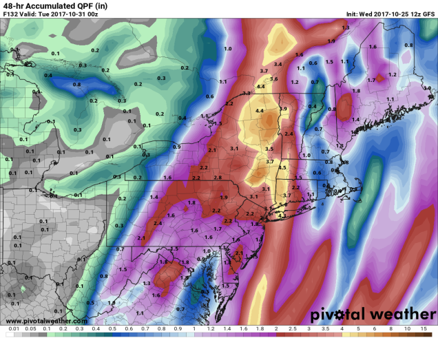
Between the rain with the current system, and the rain expected Sunday into Monday, some rivers may see significant rises, with some flooding possible. At the very least, we’ll see additional flash flooding like we saw on Tuesday from the heavy downpours.
Once that system moves out, drier weather moves in for Halloween. For trick-or-treaters, expect clear to partly cloudy skies with temperatures in the upper 40s to middle 50s across the area during late afternoon/early evening hours. Beyond that, it looks like we’ll have another system come through the region Wednesday night into Thursday, though this one should produce lighter rainfall.
