The cleanup continues after Friday’s powerful storm, but guess what? There’s another one coming! We do have good news and bad news though. The good news is that this one won’t be a strong, will contain less precipitation, the winds won’t be a strong, and the tides won’t be as high. The bad news? It’ll be colder, so many of you could be seeing some snow from this storm, potential a lot of it.
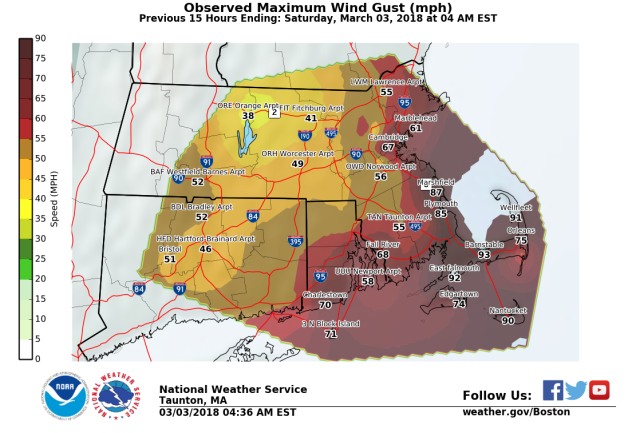
Friday’s storm is still impacting the region today, but it will finally move away late in the day. A disturbance rotating around the system produced some light snow and snow showers overnight into this morning, and winds remain gusty at times, though not nearly to the magnitude of Friday. As the storm pulls away, high pressure builds in later today and tomorrow with drier and seasonably cool conditions.

As we head into Wednesday, things go downhill again. Low pressure moving across the Ohio Valley will start to weaken while a secondary area of low pressure develops off the North Carolina or Delmarva shoreline. This system will strengthen as it heads northeastward. Another period of gusty winds is likely Wednesday into early Thursday, but this time we’re talking about wind gusts of 40-50 mph along the coast, not 70-90 mph. The system will also spread precipitation into the region. Temperatures will be a little colder, so parts of the region will see snow, possibly significant snowfall. The big question is, how far inland does the rain/snow line penetrate? Some models bring it into the 128 or 495 belts. At least one model brings it all the way into southern New Hampshire. We should have some clarity on this over the next 24-36 hours, and we’ll have a special blog post Tuesday afternoon with our updated outlook on the storm. For now, the current thinking is that from Boston southward, this is mainly rain with some snow possible, north and west of Boston, some accumulation is likely, with significant accumulations possible, especially the farther north and west you go.

Everything winds down early Thursday, but with an upper-level low pressure system moving through, some additional rain or snow showers are possible later Thursday and Friday. High pressure then builds in for the weekend, but by late Sunday, we’ll need to keep our eyes on a system moving into the Mid-Atlantic states that could impact us on Monday. We’ll worry about that system later in the week.
Monday: Mostly cloudy and breezy with some lingering snow or rain showers, mainly early. High 36-43.
Monday night: Becoming partly cloudy. Low 25-32.
Tuesday: A mix of sun and clouds. High 35-42.
Tuesday night: Becoming mostly cloudy, chance for snow showers towards daybreak. Low 25-32.
Wednesday: Windy with snow likely, changing to rain from Boston southward, possibly north and west of Boston as well. High 33-40.
Thursday: Snow or rain tapers off early, otherwise mostly cloudy and breezy. High 36-43.
Friday: More clouds than sunshine, breezy, chance for some snow or rain showers. High 36-43.
Saturday: Partly to mostly sunny and breezy again. High 37-44.
Sunday: A sunny start, then clouds start to stream in during the afternoon. High 41-48.

Has it been your experience that the Euro model tend to be most accurate. If so, what is that model showing for RI?
Thanks…,
LikeLike
It’s been our experience that none of the models have really done that well this winter, especially more than a couple of days before an event. we try not to follow just one model, but prefer to blend all the ideas.
LikeLike